|
|
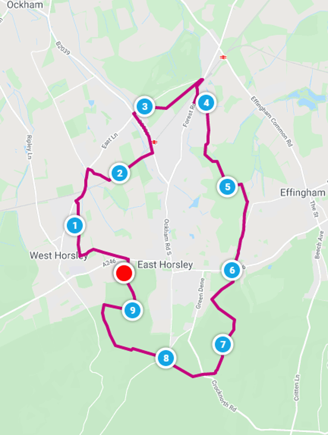
| Walk number 3 |
|
|
Effingham Common and Horsley (9.41 miles / 15.15 km / 4.25 hours):
|


 |
| Photos copyright © Graham Pearcey 2011 & 2012 |
|
Please click here for a map of the route.
|
- Use the small public car park on Epsom Road, West Horsley, Leatherhead, behind St Mary's Church, KT24 6AP.
- Leaving the car park where you drove in, carefully cross the A246 and proceed through the gate to the footpath opposite. West Horsley Place is ahead of you to the right. Ignore the yellow Horsley Jubilee Trail (HJT) waymark to the left of that, instead bearing more sharply left to take the main track that proceeds left of a fence. On reaching the treeline, bear left to find a finger post and then turn left along the edge of the next field, to reach a stile alongside a gate. Turn right along Cranmore Lane and, on reaching Little Wings, go straight ahead onto the signed bridleway, which is inclined to be very wet and muddy. On reaching a residential road, turn right alongside Fairlawn, enter a field and go immediate left aiming for the next corner of the field, whence you follow a narrow path and a driveway to arrive in The Street.
- Turn right but cross to join a safe pavement. Proceed under the railway bridge and when Long Reach is on your left, turn sharp right up Lollesworth Lane.
- Cross the railway bridge ahead and turn left to follow the footpath parallel to the railway all the way to the village hall. Here continue straight ahead to emerge onto Ockham Road South.
- Turn left (do not cross the road), proceed under the railway arch to Ockham Road North and keep going. After passing Glenesk School on your left, cross the road when a pavement starts on the other side. Turn right into The Drift, and right again when you see an information board. Enter The Forest. Follow the path closest to The Drift until you see a Public Footpath sign, then turn right. Proceed uphill, following the HJT waymarks, and turn left at the 'T junction' at the top. Shortly go straight ahead at a cross-paths, and follow a widening track. Eventually a footbridge appears that leads back to The Drift.
- Just before this footbridge, turn right onto a well-worn path. (If this path is flooded you can simply join The Drift, but beware traffic.) This leads to the junction of The Drift and Forest Road. Here go right along the pavement to cross the railway bridge and take the third road on your left, Heathway. Stay on this road until it bears right with a grassy field ahead, and shortly after this take the bridleway on the left, soon turning right onto another bridleway to proceed along the right-hand edge of Effingham Common (to the backs of houses and gardens) to the top corner of the common.
- Turn right to cross the road (Heath View), diagonally left, then continue along the bridleway (not the footpath), ignoring turnings on the right until you reach the HJT waymark directing you into Great Ridings Wood on your left. Enter the Wood, fork right within 50m at the first waymark then keep going for some time following yellow arrows until you cross a bridge to reach a wooden bench seat. You have reached the half-way point of the walk.
- Proceed uphill ignoring a yellow arrow pointing left; at the top, emerge though a fence into Orestan Lane. Go left and after a while pass a gate on your left then almost immediately turn right, following yellow markers through Parrotts Copse (keeping straight on at all cross-paths). Emerge on Old London Lane. Go left.
- At the end of the lane, the sign opposite reads Calvert Road. Bear right; this is Dirtham Lane and soon reaches the A246 Guildford Road. Turn right and carefully cross the road to follow the bridleway (not the private entrance). In about 30m bear left (ignore the right fork, a permissive footpath) and continue along the bridleway to the next waymark where you turn right past the other end of the permissive footpath, to leave the HJT. Theres a wire fence on your left; then a cross-paths; and later on there are wire fences on both sides. At an unmarked crossing of bridleways go left. Follow a narrow sometimes overgrown path between two fields until you see Stoney Dene (Lovelace) Bridge. Turn right before the bridge. Proceed uphill on the narrow path, turn left at the end and immediately sharply back right to join the path that comes from the top of Stoney Dene Bridge. Proceed along an avenue of old yew trees, turn right at a T-junction onto an often muddy track, and later pass an "Oldlands" sign to your right (facing away from you).
- Beyond this sign, the path may be muddy for a while. On arriving at the Crocknorth Farm buildings, turn right to reach a main road. The bridleway continues on the other side of the main road and passes under three Lovelace bridges (go straight at cross-paths just before the second and third bridges). If you encounter thick mud under any of the bridges, you can climb over via the bank instead. Eventually reach a road junction. Honeysuckle Bottom is signed to your left, but you bear right.
- Carefully cross the main road and take the bridleway opposite, all the way uphill ignoring side turnings until you reach a three-way finger post. Follow the left-hand bridleway, continually bearing left until the next finger post, then right. Stay on this path until the junction alongside a wooden bench seat, then head right downhill and second right at the signpost with a yellow arrow. This leads past a picnic area to Millennium Viewpoint. Follow the path down the grassy slope from the viewpoint, bear left and then go up another grassy slope on the other side of the valley. Merge with another path from the right, and keep following HJT and St Marys Car Park signs until before St Marys Church you spot vehicles parked beyond the trees to your left, so you head that way to return to your car.
|
|
This route was last walked on 12 January 2024, and the directions were accurate then. Please e-mail me if you find any errors, if you would like a copy in Word format, or if you would prefer a version that starts and ends at Horsley station.
|
|
Return to my Surrey walks page.
|
|


