|
|
| Walk number 7 |
|
|
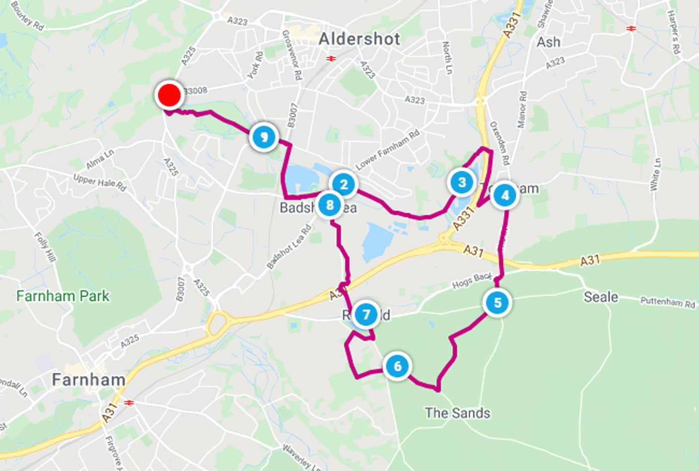
Blackwater Valley and Runfold (9.98 miles / 16.06 km / 4.00 hours):
|


 |
| Photos copyright © Graham Pearcey 2011 & 2012 |
|
Please click here for a map of the route.
|
- Use the Field Centre car park on Cranmore Lane, Aldershot, signed Rowhill Nature Reserve, GU11 3BD.
- Leave the car park at the opposite end from The Rowhill Copse Visitor Centre, taking the path signed Blackwater Valley Footpath (BVF). Follow this path avoiding all turnings downhill (left) and note an information board (left) about the Source of the River Blackwater. Bear right as you pass the pond, and soon afterwards fork left (downhill). When faced with a No Entry gate turn right; otherwise go ahead on the main path at all junctions. Fork right before reaching a green field in order to follow the right hand edge of this field. Subsequently proceed on the rightmost (the rougher) of two parallel paths to eventually emerge on a residential road called Parkland Grove, and at the T-junction turn left. Remain on the left hand pavement of Weybourne Road noting The Duke of York pub (left) and admiring The Old Cottages (opposite). After going under a railway arch, immediately turn right onto the recently upgraded footpath parallel to the railway line.
- At the end of this footpath turn left into Lower Weybourne Lane, but as the road bears right continue straight ahead on the streamside footpath. Ignore roads or bridges off this path until you reach Badshot Lea Road. Turn left and immediately after the small red-brick bridge over a stream, right onto the surfaced BVF which follows the stream and after about eleven or twelve minutes forks right to continue via a squeeze stile. When you reach a small fenced bridge, proceed straight ahead with Aldershot Park on your left. At the far right hand corner of the park, continue to follow the streamside path until you emerge at the edge of a housing estate. Leaving the BVF behind, turn right and go under a road bridge, then immediately right again through a metal gate (which may appear padlocked, but isnt) into Tongham Community Wood. Follow the main path ignoring all turnings on the left, until you bear left to follow a straight path (in line with telegraph poles) to another metal gate (also unlocked) by two rows of garages.
- Beyond the garages, turn right into Garbetts Way and at the T-junction left into Grange Road. Pass The White Harts car park and then the pubs frontage to turn hard right into The Street. Immediately cross to take the safe pavement, which goes past the Hogs Back Brewery, under the A31, under a second road bridge (Thundery Hill Bridge) and then left as the pavement zigzags downhill to emerge on a country lane (Thundery Hill). After passing houses, reach a crossroads and proceed along the footpath diagonally right in front of you signed No Horses. You have reached the half way point of the walk.
- After some time meet a driveway. Carefully cross this driveway (beware cars) and soon reach a road (Blighton Lane). Turn left. Ignore the signed North Downs Way (NDW) on the left; some time later, pass Farnham Golf Clubs course (left) and clubhouse (right), and reach a T-junction where you turn right and follow Sands Road.
- After some time, as a road junction comes into view ahead, look for house number 5, Swiss Cottage (right), and here take the NDW left to another road. Turn left, then immediately right, following the NDW into woodland.
- When you come to the end of houses (right) and bungalows (left), turn right onto a wide bridleway. In about 100 metres, do NOT follow the NDW left up steps; instead, continue straight ahead to a road, then turn right. As the road bends left, cross to a safe pavement, and then as the road bends sharply right turn left onto a signed Public Footpath. Pass Runfold Pool to your left. Emerge by Inspire Upholstery, turn left and pass Thatchers Motors before turning right into St. Georges Road. After youve crossed the A31 by means of a road bridge, turn right (also signed St. Georges Road), then descend via steps (often slippery) to your right and proceed along a lane. Ignore side turnings and continue straight ahead at Oak Tree View, to emerge further along St. Georges Road.
- Turn right and cross to take the safe pavement towards the village. Then take the first road on the right (Low Lane), eventually reaching a main road. Turn right and immediately cross to the left hand pavement, taking the signed footpath just beyond the Farnham Van Sales forecourt to retrace your steps to your car via Lower Weybourne Lane, the footpath parallel to the railway line, the railway arch, Weybourne Road, Parkland Grove and Rowhill Nature Reserve.
|
|
This route was last walked on 1 April 2024, and the directions were accurate then. Please e-mail me if you find any errors, if you would like a copy in Word format, or if you would prefer a version that starts and ends at Aldershot station (add 2.50 miles/ 1.00 hours).
|
|
Return to my Surrey walks page.
|
|


