|
|
| Walk number 9 |
|
|
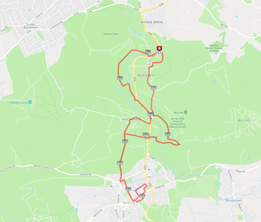
Box Hill and Mole Gap (10.25 miles / 16.50 km / 5.00 hours):
|


 |
| Photos copyright © Graham Pearcey 2011 |
|
Please click here for a map of the route.
|
- N.B. Denbies Wine Estate footpaths may be closed on a Sunday.
- Park on London Road, Mickleham, alongside the 51 degrees NORTH café, RH5 6EH.
- Turn into Byttom Hill (at the far end of the café), then take the footpath alongside The King William IV pub, that climbs to a cross-paths. Turn hard right and follow the track ignoring a subsequent footpath to the right until you reach an apparent dead end, where you bear right to reach the top of Dell Close. Start to walk along Dell Close, past the Village Hall, until just before Rectory Cottage you reach a crossing of footpaths. Turn left to pass through the churchyard, keeping the church to your left, and emerge onto Old London Road opposite The Running Horses pub. Turn left. Cross to the right hand pavement. Follow this pavement, all the way (two thirds of a mile) to the public car park at the foot of Box Hill (for part of the route, it turns into a footpath that runs parallel to Old London Road).
- Cross the road at the bus stop, just before The Burford Bridge Hotel. Climb through the gate then go right up shaded steps. The path gradually becomes chalky, and can be slippery when wet. Eventually you see it come to an end under trees, and you bear left to proceed on grass. Cresting the first hill, follow a Stepping Stones Walk sign to continue your ascent on either of two parallel paths. Pass through a gate then ignore both a left fork and a few left turns, until the path gets quite narrow amongst the trees and reaches the gravestone of Major Peter Labellière.
- 60m after the gravestone, turn left. A sign reads Riverside Walk. Pass the entrance to Swiss Cottage on your right. Straight ahead is a National Trust car park, but you bear right onto the pavement which leads in a short distance to the summit viewpoint and memorial to Leopold Salomons, where you can admire the wonderful views of the Surrey hills.
- Here turn sharply back right onto a descending path, part of the North Downs Way (NDW). This briefly rises again before forking left down steps. Keep right at each marker post until, arriving at the valley floor, you follow the sign to cross the River Mole via the footbridge. Then immediately bear left to climb to the Stepping Stones Car Park. Turn left onto the A24 but then carefully cross both carriageways to proceed along the NDW through a gate and under a railway arch. Pass through another gate then, after about five minutes, reach a cross-paths (signed for Dorking and for Westhumble) where you go left through a broken gate into Denbies Wine Estate. Maintain direction to pass the estate buildings over to your left, and keep straight ahead at a cross-roads.
- When the main track bends right, your route continues straight ahead through a gate to a three-way finger post where you bear right (signposted Dorking), and maintain direction on Yew Tree Road until you reach the main road (Ashcombe Road). Turn left along the pavement. Look out for a narrow path between houses 62 and 64 on your right. Cross Ashcombe Road and follow this path.
- Beyond the railway bridge maintain direction along the right hand edge of Meadowbank Recreation Ground. You have reached the half way point of the walk.
- After passing the entrance to Dorking Wanderers football club, cross Pippbrook to Mill Lane and Malthouse Youth Centre (formerly The Malthouse pub). Keep ahead to reach High Street opposite The White Horse hotel. From here turn left. Take the first right into Dene Street, then left up Heath Hill where the road opens onto Cotmandene. Keep left along the perimeter wall of the Almshouses and descend left via Moores Road to emerge further along High Street alongside a petrol station. Turn right and when you get to Dorking Halls youll see a bronze relief in the entrance, commemorating the composer Ralph Vaughan Williams who lived in Dorking. Here cross Reigate Road, enter the Pippbrook Council Offices complex, and follow three Dorking and Deepdale stations signs to pass to the right of Pippbrook House (formerly the Public Library) and descend onto Old London Road opposite Fairfield Court.
- Turn left. Cross Old London Road after passing Pippbrook Mill. At the bend beyond the mill, take the narrow path between Tutts Close and Tweenways, then turn left to cross the first bridge. Follow Wathen Road to number 26, where theres a blue plaque marking the birthplace of (Sir) Laurence Olivier. Continue to High Street and turn right. Pass the Post Office and take the second road on your right, Mill Lane. Retrace your steps to the broken gate beyond the Denbies Wine Estate buildings via Meadowbank, Ashcombe and Yew Tree Roads and the estate itself. But now follow the signs to Westhumble which take you across the track, across a field via two new swing gates, and along a footpath behind the back gardens of houses.
- Cross a tarmac lane, and proceed along a narrower footpath until it ends. Go right and, at the entrance to Pilgrims Way, continue on the right-hand pavement as it proceeds behind trees. The archway to Leladene appears on your left with a blue plaque commemorating the 18th-century novelist Fanny Burney. Bear right over the railway bridge, and follow the pavement which starts on the left hand side of the road beyond Box Hill and Westhumble Station, then crosses to the right as you approach Stepping Stones pub. Before reaching the main road cross back and follow the pavement down to the subway (ignore the subway) and back up to street level.
- This pavement now crosses the River Mole, reaches a roundabout, then you proceed for about eight minutes alongside the A24. The path along this section is shared with cyclists, so beware. After bearing first left and then right, take the Public Footpath (look for the well-hidden sign) left down to a railway arch. Beyond the arch, turn right to follow Public Footpath signs across a sometimes muddy field until you pass through a kissing gate (marked as FOOTPATH) to a cream-coloured house (Cowslips). Follow the driveway until, just before a barn, you turn left (signposted Leatherhead) to cross the Mole again. At the entrance to Lodge Farm go left through a new kissing gate, then right. Ignore the right turn signed Footpath Mickleham, enter and leave Swanworth Picnic Site via two kissing gates, and bear right onto a slowly climbing track. At the very top go right onto a tarmac drive (Public Bridleway Mickleham) that zigzags down towards Norbury Park Farm. But at the first left bend in the zigzag, bear right onto a narrow descending path (look for the partially hidden Public Bridleway sign) that merges with another path from the right. At the end, turn right to cross the Mole for the last time. Turn left at the A24 and, on reaching a bus stop, carefully cross both carriageways to return to your car.
|
|
This route was last walked on 19 February 2024, and the directions were accurate then. Please e-mail me if you find any errors, if you would like a copy in Word format, or if you would prefer a version that starts and ends at Box Hill and Westhumble station.
|
|
Return to my Surrey walks page.
|
|


