|
|
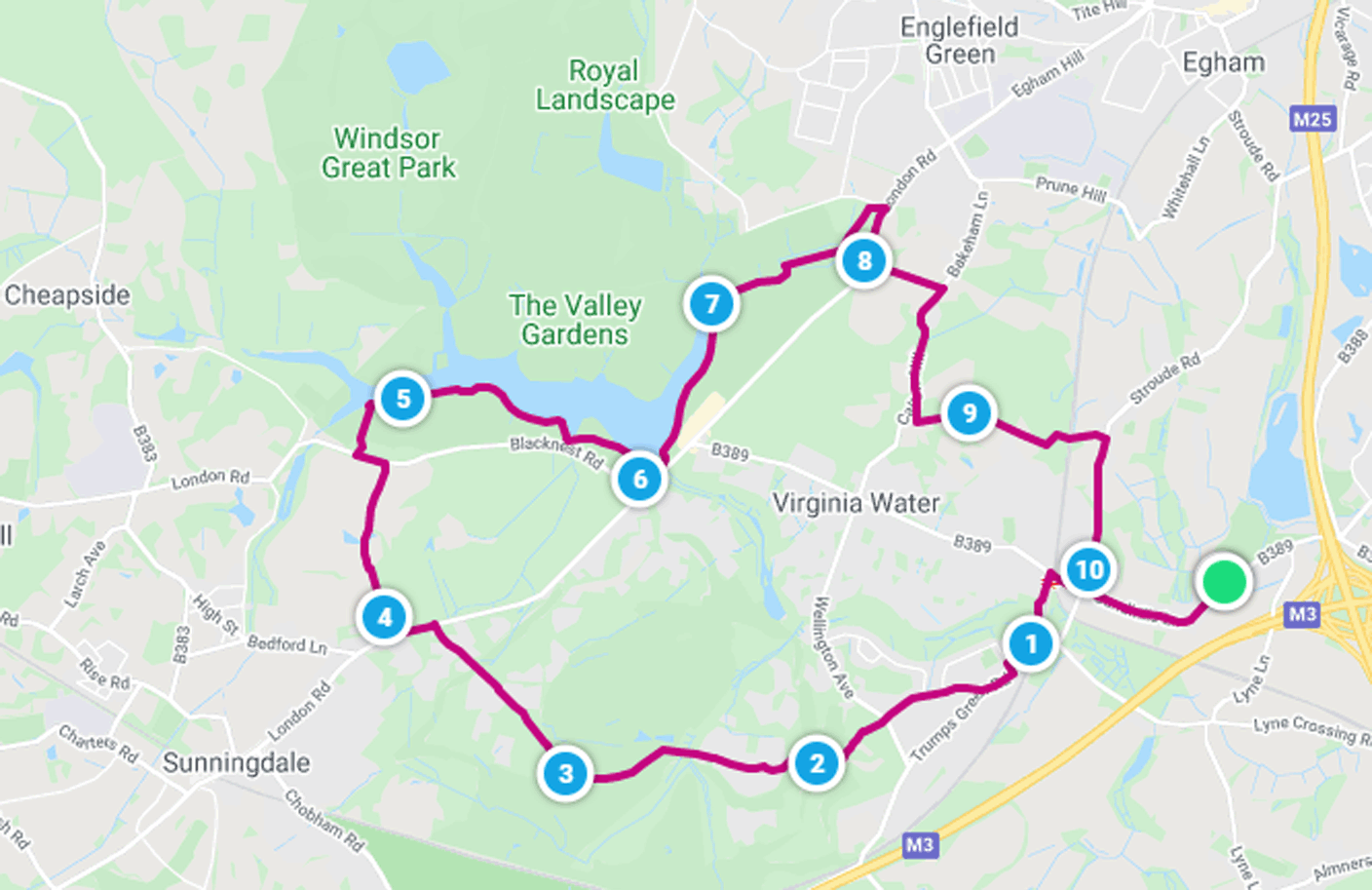
| Walk number 10 |
|
|
Virginia Water and Wentworth (10.63 miles / 17.11 km / 4.50 hours):
|


 |
| Photos copyright © Graham Pearcey 2011 & 2012 |
|
Please click here for a map of the route.
|
- Use the public car park on Green Road, Thorpe, alongside The Rose & Crown pub, TW20 8QL.
- With your back to the pub, turn right onto the main road, which immediately becomes Sandhills Lane, but DONT cross the road until after ten minutes you reach a cross-roads with pedestrian lights. Here cross diagonally to take the left hand pavement along Christchurch Road. This crosses the railway via a road bridge in about 300 metres. Then descend via steps (left) to the station car park.
- Take the footpath indicated by a Riverside Walk & Nature Trail sign. Ignore all turnings off to emerge at the edge of a housing estate. Turn right here into Trumps Green Avenue; go left at the cross-roads into Beechmont Avenue; turn right again to pass a parade of shops; and proceed uphill as far as the junction with Crown Road. Walk the full length of Crown Road, then cross Wellington Avenue to take the public footpath beyond the small car park opposite. Continue along the track, uphill. At a three-way junction of paths on Wentworth Golf Course, follow the public footpath sign right, going downhill, to reach another sign in about 100 metres. Turn right. In about 30 metres, follow the path into woods, to emerge by Fox Meadows. Proceed to the tarmac road. Follow West Drive for over a mile as it meanders through the Wentworth Estate and crosses the fairways (where you may be held up briefly during PGA Championships). Emerge onto the A30 (London Road).
- Turn left and proceed along the pavement. In about 300 metres, cross the road just before the modern dwellings (Sunningdale Villas) on the right hand side. Here follow the Public Footpath & Bridleway sign. Initially a gravel driveway, it turns into a possibly muddy track. The track eventually joins a tarmac driveway. Maintain direction at The Barn car park; then the road bears right and passes an hotel (right). At the junction with the A329, go left to the Virginia Water South car park, about 200 metres. Cross carefully into it, then enter Windsor Great Park via the pedestrian gate. Take the broad path straight ahead to the lake. Glance left to view the Five Arch Bridge, but turn right and follow the lakeside path. Pass a viewpoint (which affords a good view of the old boathouse on the opposite side of the lake). You have reached the half way point of the walk.
- Proceed past Roman ruins (right), the Cascade (left), and the Virginia Water Pavilion (right). From here continue a further half mile along the lakeside, and cross Wick Pond Causeway to reach the Totem Pole. After circling the pole, cross back over Wick Pond Causeway then immediately bear left across grass to join the path that runs parallel to the stream. Continue to a bend where the stream goes underground; bear left then immediately turn right at a staggered junction onto an unmarked shady avenue. Keep on until you first hear and then see the A30. After merging with a path from the right, bear right twice to emerge onto the A30 via a metal gate in the corner of the park. Turn right on the A30 but start to look out for a Public Footpath sign amongst the trees on the other side of the road (opposite street lamp number 85). Take this footpath, proceed alongside the playing fields and maintain direction to reach Callow Hill, where you turn right and follow the pavement. After passing The Rose & Olive Branch pub, at the bend on the hill, cross the road to take a sometimes muddy bridleway the short distance to a T-junction.
- Turn left. After passing two luxury gated dwellings on the right, fork right to follow the footpath through woods to another residential road. Here follow the Public Bridleway to Stroude Road sign, downhill, eventually crossing the railway line. At Stroude Road turn right but cross to take the safe pavement. Continue to the entrance to St. Anns Park. Here follow the bridleway sign and subsequent footpath sign. Yellow markers guide you along a right hand pavement then a left hand one. Another footpath sign now takes you left before more yellow markers guide you right towards a service road. Turn left onto Sandhills Lane and retrace your steps to your car.
|
|
This route was last walked on 26 April 2024, and the directions were accurate then. Please e-mail me if you find any errors, if you would like a copy in Word format, or if you would prefer a version that starts and ends at Virginia Water station.
|
|
Return to my Surrey walks page.
|
|


