|
|
| Walk number 12 |
|
|
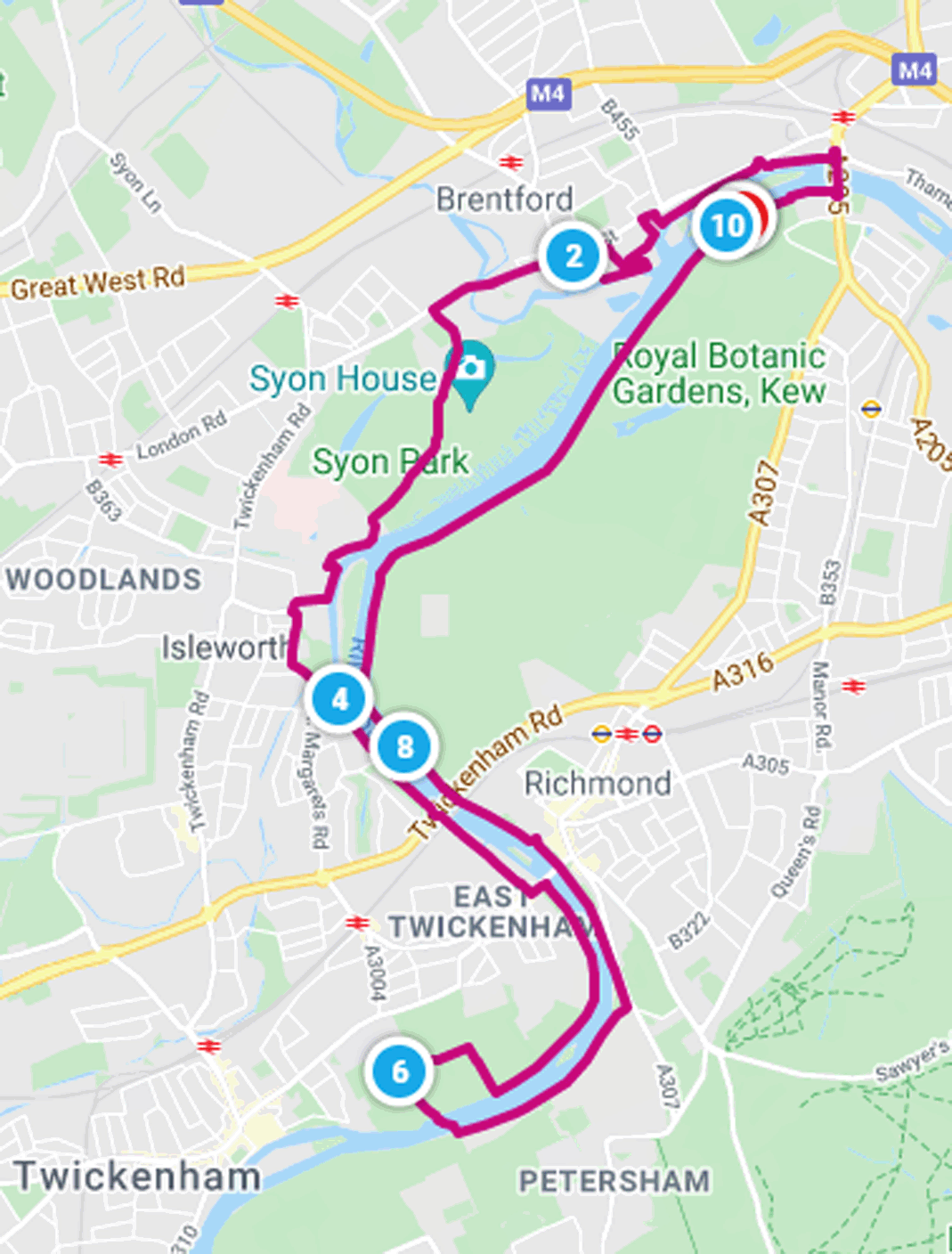
Marble Hill and Kew Bridge (10.04 miles / 16.15 km / 4.00 hours):
|


 |
| Photos copyright © Graham Pearcey 2011 |
|
Please click here for a map of the route.
|
- N.B. ferry (£2) operates from 10am – 6pm or dusk if earlier, with a lunch break from 1pm – 1:45pm: December – February, weekends only; March – September, all week; October – November, closed.
- Park (£9) in Ferry Lane, Richmond, TW9 3AG.
- From the car park climb any set of steps to the towpath and turn right so that the river is on your left. After passing the backs of various properties, you reach Kew Bridge. Immediately before the arch, descend steps to your right then climb the staircase (signed Kew Bridge Station). Turn left to cross the river then turn left down a staircase to reach the Thames Path, turning right to proceed upstream alongside houseboats. Ignore several sets of steps that ascend to apartments or to High Street, instead continuing riverside of flats until you’re facing a “Victoria Steps Quay” sign – where you ascend via steps to emerge opposite The Musical Museum.
- Turn left on High Street but as soon as possible descend (left) into Watermans Park and continue riverside of Watermans Arts Centre before a gate (designated “Fire Assembly Point”) returns you via more steps to High Street. Turn left. After passing a parade of shops on the opposite side of the street, turn left into Goat Wharf and right at the river, signed “Thames Path”. After the Galata Pera restaurant on Ferry Quays, turn hard right to proceed via Town Meadow back to High Street for a third and final time.
- Turn left and proceed straight along High Street without digression, all the way through Brentford town centre (half a mile) until it crosses the River Brent and becomes London Road.
- After passing a newsagents, turn left to follow the pedestrian route to Syon Park. Maintain direction alongside the car park (right). After passing the Syon Park Visitor Entrance, bear left and follow the gravel footpath all the way to the exit gateway from the park. Turn left and pass in front of Isleworth Parish Church (All Saints’) before continuing along Church Street and reaching a small bridge. Immediately after the bridge take the path on the left (unmarked) that passes a crane and continues along the river. Turn right immediately beyond the Town Wharf pub, into Swan Street, then left into North Street. Proceed straight ahead into Richmond Road (which is to the left of The Castle pub). Just after the small bridge, turn left into Railshead Road to reach a riverside park. Pass the decorative Richmond Lock footbridge; and under Twickenham Bridge and a railway bridge; then proceed along Ducks Walk to reach Richmond Bridge.
- Here turn right, take the safe pedestrian crossing, turn left onto the slipway leading back to the river, and then continue upstream along the towpath. Eventually pass luxury flats and an old house, and proceed to Cambridge Park Footpath, on your right. You have reached the half way point of the walk.
- The towpath soon passes alongside the Marble Hill grounds. A “summer gate”, at the bottom of steps, leads into the grounds. Ignore this gate but proceed to a second, wider, gate and enter the grounds there. Proceed along the main path, passing a black walnut tree (reputedly one of the largest in the country) on your right and Henrietta Howard’s grotto on your left. Take the third path on the left (signed ‘House’) to pass in front of Marble Hill House and an ice-house on your left and the former Coach House (sometimes open as a café) on your right before emerging onto a lane opposite Park Cottages. Turn left and beware cyclists. When you arrive back at the towpath, turn left and in a short distance reach Hammerton’s Ferry. Take the ferry back to the south bank of the Thames.
- On disembarking the ferry, turn left to follow the towpath back to Richmond Bridge - a walk of about 1.25 miles. Along the way you get a fine view of the back of Marble Hill House on the north bank and the former Royal Star and Garter Home appears on your right, perched high on Richmond Hill.
- From Richmond Bridge, continue along the towpath, prone to severe flooding. (If affected, divert via Water Lane, King Street and Old Palace Lane. Add 0.25 hours to the total walk.) Pass the railway bridge and Twickenham Bridge that you earlier passed on the other side of the river. (Just after Twickenham Bridge, you cross the original pre-1884 meridian line and note a sign inviting you to spot the King’s Observatory.) The path along this route is shared with cyclists, so again beware. Pass Richmond Lock footbridge on your left and later look out for All Saints’ across the river. Shortly after this, cross the old meridian line again before passing the Old Deer Park on your right (this part of the Park is now the Royal Mid-Surrey Golf Club). Further on, as you draw alongside Kew Gardens, you get a fine view of Syon House on the north bank. Nearly a mile after this, Kew Palace comes into view on your right behind a car park. Retrace your steps to your car.
|
|
This route was last walked on 10 May 2024, and the directions were accurate then. Please e-mail me if you find any errors, if you would like a copy in Word format, or if you would prefer a version that starts and ends at Kew Bridge station.
|
|
Return to my Surrey walks page.
|
|


