|
|
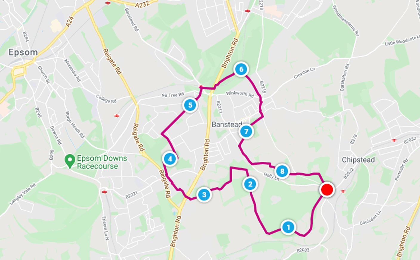
| Walk number 13 |
|
|
Banstead Commons and Nork Park (8.69 miles / 13.99 km / 4.00 hours):
|


 |
| Photos copyright © Graham Pearcey 2011 & 2023 |
|
Please click here for a map of the route.
|
- Use the large public car park on Lower Park Road, Chipstead, Coulsdon, CR5 3NR.
- Leaving the car park by the kissing gate at the top left hand (south) corner, follow the waymarked gravel path. After 75m, join the public footpath signed Perrotts Farm. Soon after, admire the wooden Aslan (lion) sculpture alongside the steeply rising path through woods to your right. But you go left and, ignoring the stile, take the more gently climbing path outside the woodland edge, to the right of a fence with views over Outwood Lane (the B2032). Continue through several tunnels of trees where two or three unmarked routes, left, lead downhill but you continue straight on. After some time a meadow appears to your right and you can walk along the edge of that if the lower path is overgrown or muddy. Beyond the end of the meadow, at a three-way finger post, turn right (signed Banstead Woods) into Fames Rough. The path narrows just before, at another three-way finger post, you turn left onto the Banstead Countryside Walk (BCW).
- Keep straight ahead when a BCW waymark points to the left, and eventually your path bears right and you leave Fames Rough by the (broken) stile at the corner of an open field. Maintain direction along the edge of the field, with woods to your right, and cross a stile to the right of all buildings at Perrotts Farm.
- Cross the farm road, and enter the new gate straight ahead. Of the two footpaths from here, take the left fork, then proceed straight on for some time.
- Your route kinks to the right to proceed along the edge of Ruffett Wood, where to your right you can see Park Downs and Holly Lane. At the end of the wood maintain direction (signed Holly Lane). Entering woodland, the path immediately crosses a track, but you turn left and proceed along this track. Just before it becomes Chipstead Road (on reaching houses), go left into the field and follow a descending path.
- The path rises again to reach another corner of Ruffett Wood. Here turn right into woodland, and then bear left into a field before proceeding along the right hand field edge and back into a smaller area of woodland. Go through a kissing gate. Follow the right hand field edge straight on (signed Burgh Heath), with trees to your right, to a (broken) four-way finger post, and continue across another field (also signed Burgh Heath) towards a gap in a hedge. Carry straight on along another field with Canons Wood on your right, until you reach a kissing gate near some houses. Turn right but cross to take the safe (left hand) pavement. Just before the A217, cross back and then carefully cross both carriageways of the A217 itself to locate a footpath straight ahead.
- Follow the footpath into woodland. At the cross paths, carry straight on between fences. At the road, turn left and follow it as it bears right. At the end of the road cross over and follow the footpath alongside the yellow litter bin. At the next road (Waterer Gardens), cross over and follow the footpath to the left of the newsagents. At the end of the path, turn right and then shortly turn left onto a path into woodland.
- Carry straight on downhill until you reach a picnic area in Nork Park with extensive views towards London. Here turn right and follow the track, with a sports field to the left.
- Pass through a metal gate into a car park and maintain direction. At the end of the car park turn left to follow either of two parallel downhill paths through a long avenue of trees. You have reached the half way point of the walk.
- The tracks merge before the backs of houses appear to your right. Eventually arrive at a childrens play area. Turn right to get round this, and exit onto Nork Way. Turn right and follow this road for half a mile. Where it bears sharply left, go straight on along Eastgate. Where Eastgate bears left after shops, go straight on along a footpath. Cross the main road at the crossing and carry straight on until you reach another road. Turn left towards Banstead Station, but cross this road immediately to follow the bridleway that runs to the right of the railway track. At the end of the bridleway, carefully cross both carriageways of the A217; turn left to follow the pavement over the railway; then take the first right to enter the golf course. Bear left at the first fork then gently bear right to follow the well-worn path into a small wooded area and subsequently straight across another section of the golf course; then head downhill through more woodland till you reach another bridge over the railway. Cross it and turn right then immediate left onto a climbing path through trees.
- At the next crossways proceed straight ahead onto a wide, climbing, surfaced path; and ignore all side paths until you eventually reach Winkworth Road. Cross with care and follow the path straight ahead. Ignore a service road (Barnfield) but at the main road (Sutton Lane) turn right and cross just before you reach a roundabout to proceed along the left hand pavement of Park Road. Pass the old village well, which was still in use at the end of the 1800s, then just beyond Banstead Community Hall turn right onto a signed path leading into Lady Neville Recreation Ground. Walk straight through the recreation ground exiting opposite a post-box. Turn left along the road (De Burgh Park). Take the first footpath on the right that soon leads past allotments to reach Holly Lane. Turn left but walk along Holly Lane East (because Holly Lane doesnt have pavements). At the far end join the footpath for a short distance before turning left onto a path signed Park Downs. Follow the hedgerow trees on your left to the top corner of this field, then follow the next field edge until you come to a signpost in 50m. Turn left (signed Park Road), and take the right hand path to the end of the woodland.
- Now follow the well-worn, lower, path over Park Downs. On reaching a bench avoid climbing paths to your left but proceed straight ahead until you pass to the left of a notice board. Soon bear left to cross Park Road, looking for the BCW sign. Bear left and left again for a route that follows a fence (to your left). After about five minutes, a three-way finger post directs you right (downhill) along a permissive footpath that bears left as soon as it enters the woods. The paths a bit unclear but as you emerge from the woods you should see a BCW sign and, descending the hill, hear the traffic on Holly Lane even before you see it. Carefully cross both carriageways of Lower Park Road to return to your car.
|
|
This route was last walked on 8 December 2023, and the directions were accurate then. Please e-mail me if you find any errors, if you would like a copy in Word format, or if you would prefer a version that starts and ends at Banstead station.
|
|
Return to my Surrey walks page.
|
|


